Solutions for the optimal use of remotely acquired, high resolution data by the forest
Lead researchers: Dr Christine Stone and Dr Jim O'Hehir
The Project
The overall aim of this project was to evaluate the feasibility of effectively harnessing the 3D information captured by new LiDAR (laser scanning) technology capable of acquiring dense point cloud data for improved resource assessment by commercial plantation growers.
The project proposed four deliverables, ie:
- Provide recommended specifications and procedures for optimal data acquisition and on-screen 3D visualisation and assessment of individual tree stems using point cloud data captured by a multi-rotor LiDAR-UAV.
- Provide recommendations on the feasibility of generating accurate 3D models of tree stems for product mix assessment using ultra-dense point clouds acquired by a LiDAR UAV.
- Provide recommendations on any operational constraints for practical forest operations using LiDAR acquired from a UAV.
- Provide recommended specifications and procedures for the data acquisition, processing and analysis of dense point clouds acquired by light aircraft for plantation resource assessment and mapping.
Our Research Approach
The project was structured into seven subprojects such that each research partner and team could identify the workstram that they need to undertake and report on via a shared, cloud-based directory:
- Ultrahigh-resolution imaging from unmanned aerial systems for detection of weeds and tree health assessment (Arko Lucieer and Darren Turner, Uni Tas)
- Automation of forest inventory (Mitch Bryson and Lloyd Windrim, Uni Syd; lnterpine)
- Monitoring forest properties at the individual tree level using UAV-borne Sensors (Anthony Finn and Pankaj Kumar, UniSA)
- Growth and yield modelling for the future (Stefan Peters and Pankaj Kumar, UniSA)
- Hyperspectral detection of nutrient deficiencies in radiata pine (Michael Watt, Scion)
- Investigation of data management and processing options forest industry (Jixue Liu and Jiuyong Li, Uni SA)
- Remotely sensing native Jarrah forests (Arko Lucieer, Uni Tas and Mitch Bryson (Uni Syd)
Half hour mini seminars have been delivered with good attendances and four virtual workshops with industry have been scheduled to ensure the outputs are transferred to industry. For futher information on the mini seminars, contact Dr Jim O'Hehir.
Key Findings
Ultrahigh-resolution imaging from unmanned aerial systems for detection of weeds and tree health assessment
Data was collected at three pine plantation sites in Northern Tasmania using a range of sensors: hyperspectral; multispectral; visible and thermal, with the aim of testing which sensors are best at detecting weeds.
Automation of forest inventory
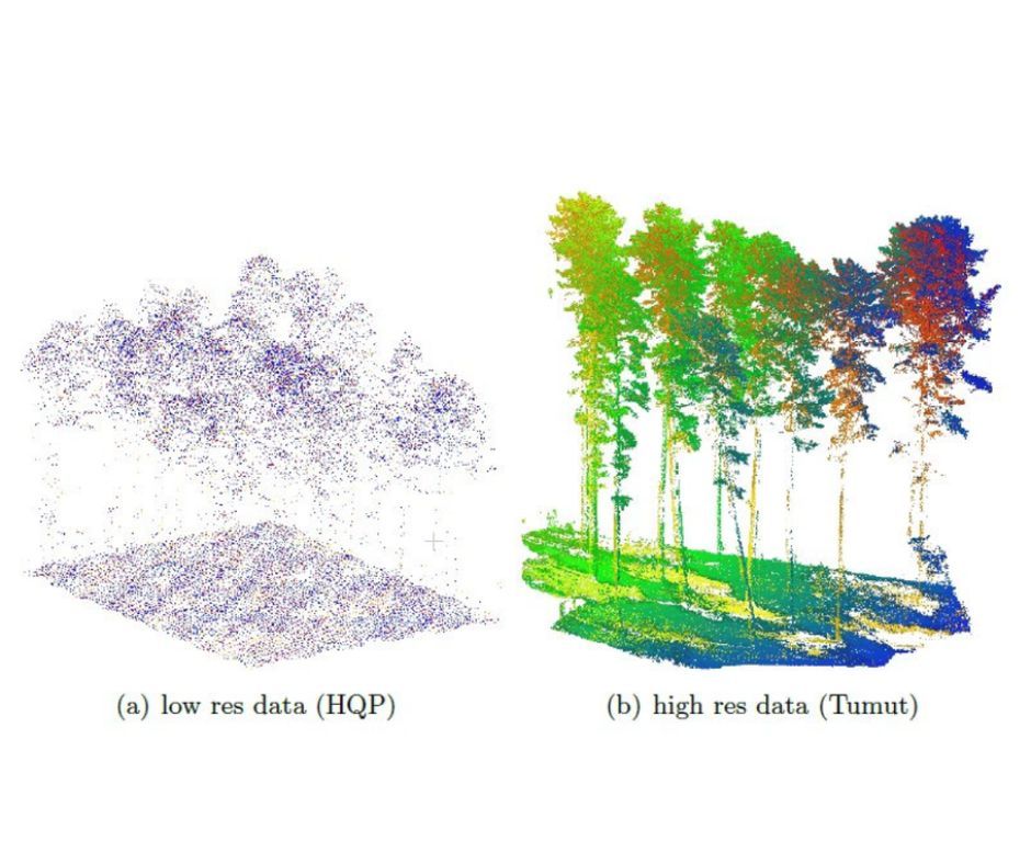
The subproject has progressed development of workflows and algoriths for tree-leve census using point clouds, deep learning and human-machine interaction. Research indicated tree detection methods developed for high resolution Airborne Laser Scanning (ALS) data based on deep learning object detection could also be applied effectively to low resolution ALS data. The implication for forest companies is that using this method, cheaper data can be used to obtain more tree attribute information.
Monitoring forest properties at the individual tree level using UAV-borne sensors
Two approaches have been develped to undertake survival counts of young radiata pine plantations from pre-processed Hyperspectral and Phantom UAV images. Both methods work but the second approach has been found to be more accurate and cost-effective in terms of estimating tree survival counts. Most plantation companies already have the equipment to capture the necessary data and allow the companies to estimate replanting costs to make more informed decisions.
Growth and yield monitoring for the future
The subproject has incorporated ground truth data into plot imputation models and shown that potential to increase the efficiency, and low ther costs, of ALS surveys by reusing calibration plot data both spatially and temporally.
Hyperspectral detection of nutrient deficiencies in radiata pine
This subproject has demonstarated that generalised field predictions of photosynthetic capacity can be made using only remote sensed reflectance data. This will benefit the industry by improving the assessment of plantation nutrient status at a fraction of the cost and complexity of manually collected and analysed methods.
Investigation of data management and processing options for the forest industry
This subproject has resulted in the development of a report which draws on the literature to compare options for forestry data management with an emphasis on large data sets.
Ultra-Dense Point Clouds for Inventory (Interpine)
Interpine have continued working on implementing forest inventory using a backpack LiDAR scanner. The resulting scans are being incorporated in a vitrual reality application (VRForest) and these results are then available for use in forest resource planning software.
What is the future of R&D for Remotely Acquired Data?
- Improved understanding and capacity to deploy unmanned airborne vehicles carrying different active (LiDAR) and passive (optical/spectral) sensors.
- Improved understanding of the optimal configuration (ie optimal spatial and spectral resolution) of these systems (UAS) for a range of operational tasks; this may include the opportunities of using UAS acquired data for training satellite imagery.
- Workflow solutions for acquiring, processing and analysing data acquired by these unmanned airborne systems.
- Recommendations of the requirements for sensor calibration for collection of high quality spectral data.
- Recommendations related to the management of 'Big Data' including storage infrastructure, data transfer and communication networks.
Our Team
Researchers: Anthony Finn, Jim O'Hehir, Stefan Peters, Pankaj Kumar, Jiuyong Li, Jixue Liu, Liang Zhao, Christine Stone (NSW DPI) , Arko Lucieer (University of Tasmania), Paul Turner (University of Tasmania), Darren Turner (University of Tasmania), Mohammed Sadegh Taskhiri (University of Tasmania), Sean Krisanski (University of Tasmania), Mitch Bryson (University of Sydney), Lloyd Windrum (University of Sydney), Michael Watt (Scion, NZ), Susana Gonzalez (Interpine), Jan Rombouts (OneFortyOne), Hans Blom (FPC, WA), Irfan Iqbal (FPC, WA)
Collaborators: Australian Bluegum Plantations, FCNSW, Forico, FPC WA, Green Triangle Forest Products, HQPlantations, HVP Plantations, Midway Plantations, OneFortyOne, PF Olsen, Sustainable Timber Tasmania, Timberlands Pacific.
Contact information
Dr Jim O’Hehir
General Manager: Forest Research Mount Gambier
Ph: +61 8 830 28997
E: Jim.O'Hehir@unisa.edu.au
Michele Cranage
Administrative Officer
Ph: +61 8 830 28902
E: Michele.Cranage@unisa.edu.au