Geospatial positioning and fusion: is real-time sub-metre, accuracy operationally feasible in forestry environments?
Lead researchers: Dr Stefan Peters, Professor Anthony Finn, Professor Arko Lucieer, Graham Walker, Dr Jim O'Hehir
The Project
This project seeks to offer improved forest asset management practices and value recovery through the enablement of higher precision and more accurate GNSS-based positioning and improved geospatial data processing, integration and fusion.
To enable forest managers to obtain accurate, precise, consistent and reliable geospatial tree-level positioning information; to facilitate integration of accurate and precise geospatial information with other data for a range of forestry applications; and to promote understanding amongst forest managers of the systems, technology and infrastructure requirements that are needed to achieve these goals.
Industry Partners
The University of South Australia will collaborate the University of Tasmania and with the following industry partners:
Forestry Corporation of NSW, HQPlantations, FPC, HVP Plantations, Timberlands Pacific, OneFortyOne, Midway Limited, Sustainable Timber Tasmania, SFM, AKD, Softwoods Green Triangle Forest Products, Reliance Forest Fibre, PF Olsen, Australian Bluegums Plantations
Our Research Approach
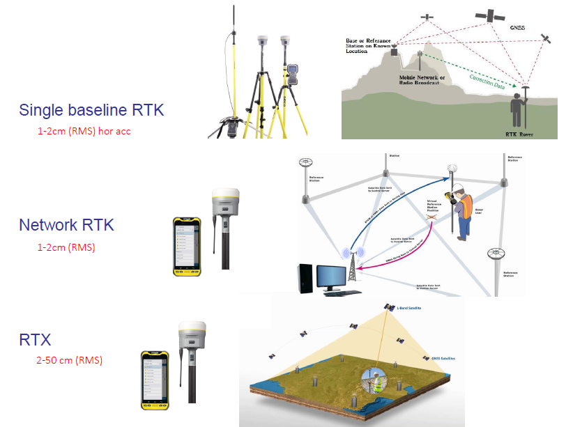
The first phase of this project will involve a Systems Analysis to establish a matrix of grower key activities requiring accurate positioning and/or data fusion, and the methods (and costs) used to capture and display location and geo-register and fuse remotely sensed data. This will provide a benchmark against which new and alternative technologies can be compared. The outputs to this phase will include a set of technology ‘business case curves’ relating cost, time, expertise, availability and robustness for new and alternative systems. For example, some operational activities may only need to be at ±10 metres (e.g. where stands of trees need to be identified), whilst others may require sub metre accuracy (e.g. where individual trees need to be identified in relation to current positions of a harvester head); and others again, may need decimetre or centimetre-level positioning accuracy (e.g. when spatially aligning 3D point-clouds of Canopy Height Maps or tree stems obtained from photogrammetric or LiDAR-derived data sets, including from different (multi-temporal) scan campaigns and aerial/terrestrial aspects).
The second phase of this project will involve identification of current and future solutions for individual tree-based geospatial forest management, which will specifically address the requirements identified in the needs’ analysis of Phase A. Preliminary conversations with industry partners have already taken place, and key aspects of the capability needs matrix are anticipated. Similarly, if it is needed, access to the Defence Science & Technology Group’s sophisticated hardware-in-the-loop GNSS environmental satellite simulator has been pre-arranged.
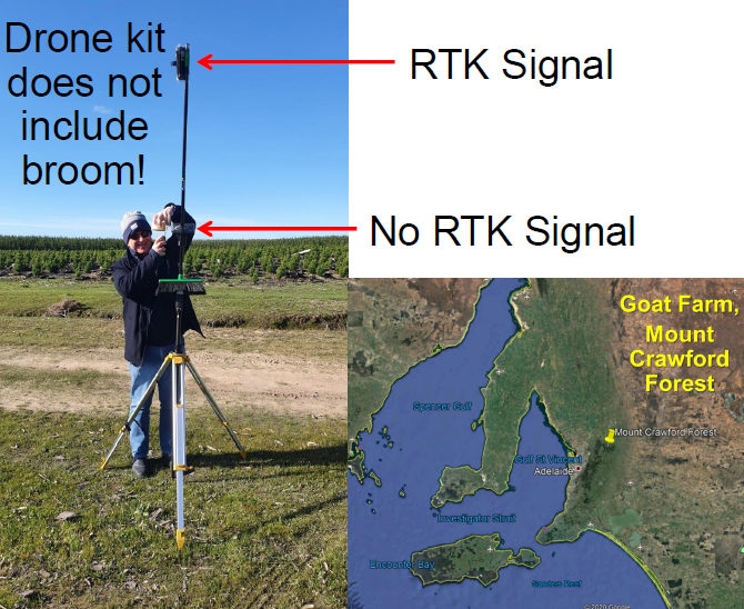
Real World 4G coverage issues
Project Deliverables
A set of tools, best practice standards, and guidelines for addressing industry cost-capability trade-offs and infrastructure requirements for a range of forestry applications that require accurate in situ geospatial positioning, geo-registration, and data fusion.
The benefits of this project are as an enabler of precision forestry. Without accurate and precise location information many of the benefits of precision forestry cannot be realised.
Project Outputs
Milestone Reports, selected journal articles, conference presentations and workshops will be produced from the research described in this project. In addition, a set of best practice standards and guidelines of options for achieving accurate/precise geospatial positioning and data fusion in forest management applications will be produced. Where appropriate, prototype software applications will be provided to all participating companies, noting that the aim is not to deliver commercial software packages but rather make available to all project participants affordable, efficient data flow processes that can provide outputs suitable for integrating into existing software systems. A report detailing comprehension of the cost-capability trade-offs required to achieve any recommended solutions will be produced.
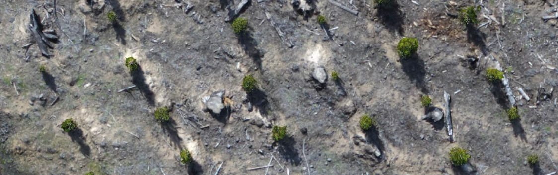
Dense Point Cloud Data: Ground Resolution: 9.5mm, Location Errors (XY): 22cm, File Size: 200GBytes (Ultra), 11GBytes (Medium)