Evaluation of remote sensing approaches for plantation health surveillance
Lead Researchers: Dianne Patzel, Christine Stone, Associate Professor David Bruce, Angus Carnegie, Sam Hislop
The Project
This project will compare a range of satellite and airborne remote sensing methods with traditional forest health assessment methods to evaluate their relative costs versus benefits in plantation health surveillance.
To compare a suite of satellite and airborne systems of differing sensor specifications with traditional aerial sketch mapping techniques, and evaluate their cost, accuracy and use in plantation health surveillance at both landscape and tree levels.
Industry Partners
The University of South Australia will work collaboratively with:
Flinders University, NSW DPI, Green Triangle Forest Health Group, Maxar / Geospatial Intelligence, SKYLAB Aerial Vegetarian Mapping GmbH, Forest Corporation of NSW, HQPlantations, Hancock Victorian Plantations, Timberlands Pacific Pty Ltd, OneFortyOne, PF Olsen, AKD, Green Triangle Forest Products and SFM Environmental Solutions
Our Research Methods
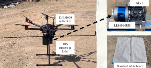
The methodology below is designed to undertake an evaluation of a suite of leading-edge remote systems and associated data-flow analytics, including their effectiveness, benefits and relative costs compared to traditional approaches applied to plantation health surveillance. Both futuristic and current systems being evaluated by companies for other aspects of precision forestry are include (e.g. SkyLab and SkySat products). This collaborative, relatively large project has a national perspective with plantation growers in all states except Tasmania, WA and NT participating, providing access to multiple regions, climates and a range of damage symptoms. The project brings together researchers specialising in remote sensing and forest health to ensure that the appropriateness of scientific robustness but also for current and future plantation management systems.
Expected Benefits
Innovation
- Innovative adoption and integration of new remote sensing systems that will improve the precision and efficacy of current practices associated with plantation health surveillance.
- Development of multiphase (temporal, spectral & spatial) monitoring techniques for differentiating damage agents and processes affecting plantation productivity.
Detection and Response
- Detection of abiotic/biotic events as they arise, irrespective of specific timelines of symptom expression, to assist industry to reduce losses, mitigate response and therefore improve plantation management.
- Increased visibility for forest managers into their respective estate without the need for site
- Increased visibility for forest managers into their respective estate without the need for site visits
Potential Impacts
Project participants will be provided with:
- Improved understanding and the capacity to deploy remote sensing methodology for plantation health surveillance.
- Recommendations for technological ‘fit for purpose’ and cost-effective approaches to plantation health surveillance using remotely acquired data.
- Improved understanding of the temporal, spatial and spectral resolution requirements for the detection of landscape level disturbance (location, extent, severity) and fine scale (stand/tree) events (necrotic, chlorotic and defoliation).
- The capacity to undertake more frequent (seasonal) observations of entire forests estates than is currently undertaken.
We anticipate the recommendations from this project will provide industry with confidence and understanding to make use of current and future remote sensing approaches in their plantation health surveillance programs.
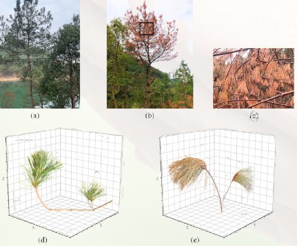
(a) and (b) The general ground situation of green pine and PWD infected pine. (c) Needle growth situation corresponding to the black rectangles in (b); (d) and (e) The needle distribution of green pine and PWD infected pine
Project Outputs
- Recommendations and procedures for the use of remotely sensed data in plantation health surveillance
- A prototype broad-scale forest health surveillance system based on the Forest Disturbance Index (FDI)
- Quantification of the costs and potential benefits relative to current approach and methodologies
- Four milestone reports at six monthly intervals plus a final report
- Peer-reviewed journal articles and conference presentations at conferences such as ForestTECH
Two workshops: 1) hands-on training session for users of the FDI, and 2) discussion with industry representatives to develop adoption pathways for an operational system.