Scoping an Automated Forest Fire Detection and Suppression Framework for the Green Triangle
Lead researcher: Dr Li Meng
The Project
The economy of the Green Triangle region is highly dependent on the forest industry and fire is the major risk. Early detection and successful suppression operations are critical to minimising loss due to fire impact on plantations, agriculture and local communities. This project was to examine the feasibility of emerging technology to enhance and automate fire detection and suppression in the Green Triangle region.
Our Research Approach
Key issues were identified in an initial project workshop with the industry partners and emergency services. The project was developed through the investigation of five sub-projects:
- Literature review focussing on state-of-the-art of staellite-based fire detection and monitoring; staellite sensor assimilation; satellite-based flammability models - Stefan Peters (UniSA).
- Fire detection methods (other than satellite) - Jing Gao (UniSA).
- Shystems and analysis and development - Anthony Hay (Esk Mapping).
- Phoenix modelling that quantifies the likely loss fro bushfire under a range of fire scenarios and management actions - Owen Salkin (Natural Systems Analytics).
- Modelling of resource and suppression, vulnerability and transport accessibility - Li Meng (UniSA).
Our Findings
Fire Towers
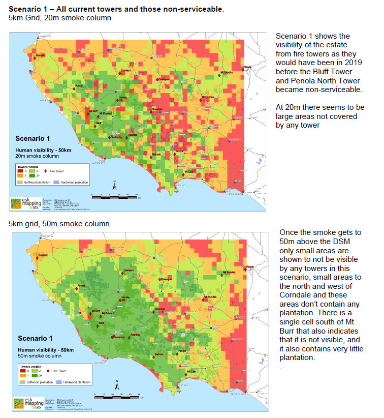
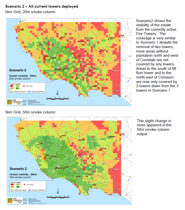
- Modelling indicated the overall robustness of the current human-operated fire tower network in the region.
- Cameras can enhance monitoring where additional height can be gained.
- Limited trials had good results for smoke sightings out to 20km, however current fire tower spotters frequently report smoke sightings 50+km.
Automation
- Reserach into improving fire detection algorithms, including fire smoke detection and sensor fusion could helpo to further improve fire hotspot precision and location accuracy.
RPAS (UVAs / Drones)
- Allow access / visibility not available to ground-based systems.
- Smaller RPAs, more readily available, can be deployed locally and have limited flight times.
- Larger RPAs, expensive, longer flight tiems, and require runways for take off.
- Use is currently restricted by Australian legislation.
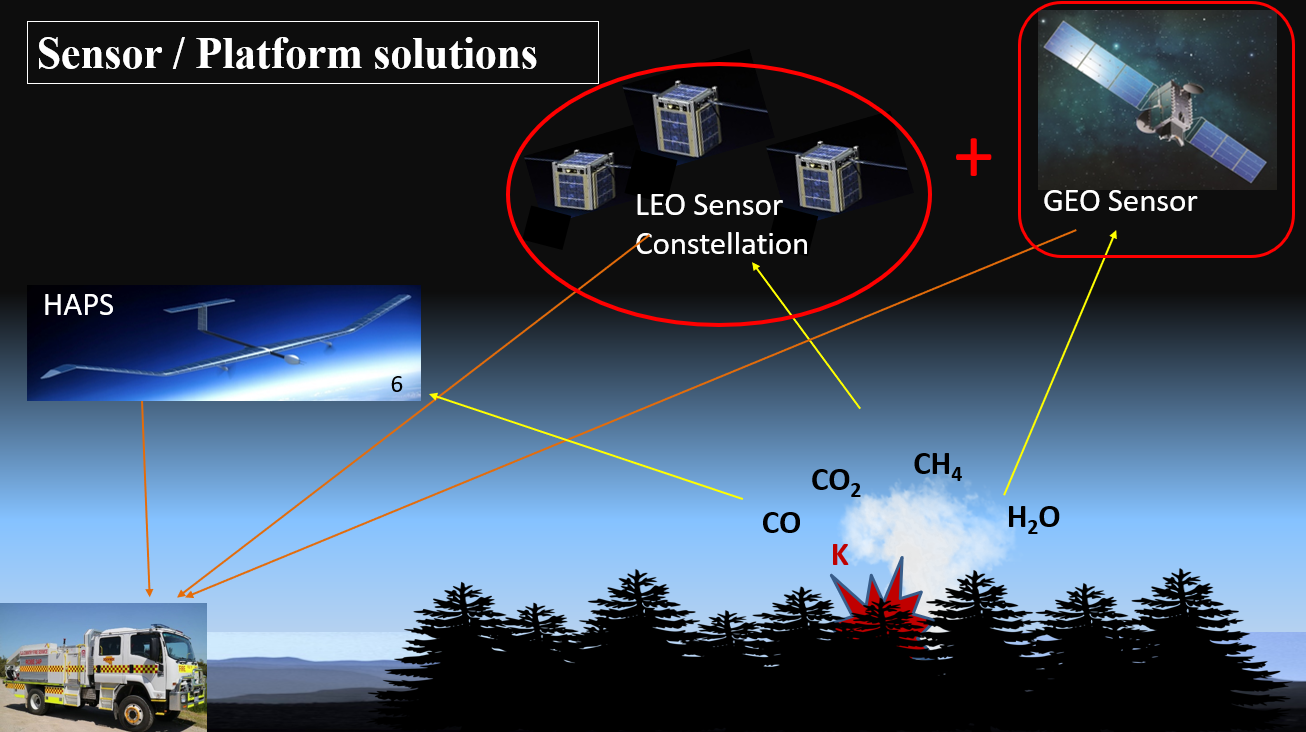
Satellites
- Current satellite sensors do not prove enough spacial, temporal and spectral resolution to detect small fires.
- Satellite paths, return times and data transission result in significant delays in detecting and reporting fires.
- Cube satellite constellations look to be promising future solutions.
Response
- There are opportunities to better tailor the deployment of suppression resources to the modelled risks in real time.
Plantation Loss
- Modelling suggested that most of the losses will occur in the very high and severe fire danger ratings and very few in the Extreme to Code Red/Black Saturday FDRs.
- Modelling of plantation area and value loss scenarios supported the industry observation of the benefit of reapidly detecting and suppressing fires.
What is the Future of R&D in Fire Detection and Suppression?
The speed of technology development is rapid hence there is a need to continually monitor developments.
Cameras
- Futher evaluation of capability.
- Optimal geographic and topographic spacing.
- Data connection requirements and costs.
- Auto-detection algorithms.
- Cost / benefits compared to human operation.
RPAS
- Operational fireground use of RPAS for intelligence gathering, including the practicality and durability under adverse weather conditions.
- Economics of larger RPAS.
Satellites
- The development of Cube satellite constellations and technology.
Fire Response
- Risk modelling informing location and quantity of firefighting resources.
- Cross-border coordinated activation.
- Effective fire ground and aerial strategies.
- What are the best combinations of people, tankers, plant and aircraft?
Our Team
Researchers: Li Meng, Jim O'Hehir, Stefan Peters, Jing Gao, Euan Ferguson (Euan Ferguson Pty Ltd), Anthony Hay (ESK Mapping & GIS), Owen Salkin (Natural Systems Analytics Pty Ltd), Greg Saunder (Forest Owners Conference)
Industry Collaborators: AKD Softwoods, ForestrySA, Green Triangle Forest Products, Hancock Victorian Plantations, Kangaroo Island Timbers, OneFortyOne Plantations, PF Olsen, Sustainable Forest Management, Timberlands, Country Fire Authority, Country Fire Service, Department of Environment and Water, Department of Environment, Land Water and Planning, Forest Owners Conference.
Contact information
Dr Jim O’Hehir
General Manager: Forest Research Mount Gambier
Ph: +61 8 830 28997
E: Jim.O'Hehir@unisa.edu.au
Michele Cranage
Administrative Officer
Ph: +61 8 830 28902
E: Michele.Cranage@unisa.edu.au