Adelaide University is now open!
For all information related to the new Adelaide University — including study applications for 2026, details for commencing and current students, and Graduate Research — please visit adelaideuni.edu.au.

Chief Investigators: Harry Rust and Dr Stefan Peters
Year commenced: 2021
Problem
Green Adelaide is dedicated to creating a cooler, greener, wilder and more climate resistant city. Green spaces play a major role in this mission, bolstering biodiversity, and improving human wellbeing. Mapping and GIS technology can systematically analyse green spaces and assist with planning efforts.
Project Summary
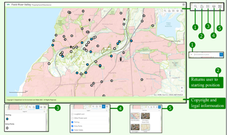
A web app was created in ESRI Dashboards that allowed us to view the map of Field River Valley greenspaces in web browsers. Numerous built-in tools enhance usability for managers, allowing easy-to-navigate maps to enhance visitor engagement and promoting holistic planning that reflects the integrated nature of the spaces.
Our project was led by a third-year Environmental Science student and offers an example of the quality of undergraduate research collaborations we can offer.
Impact
We have developed a web mapping application to investigate existing features including trails, hazards and entry points. Green Adelaide staff can use this application to navigate the site while undertaking ecological and cultural surveys. In future iterations, we plan to make it accessible the public.